Its easy to loose ones head in the face of a looming disaster, to get lost in the what ifs and worries. But there is another way. I am able to go about my day in peace, no matter what may lie ahead because I know someone so much greater than my self, someone far more capable than I, is in control. His name is God and he cares about you.
Monday, January 25, 2010
Sunday, January 24, 2010
Looking ahead next week
According to the National Weather Service, we can enjoy the sunny weekend. Isn't it nice to wake up to the sun streaming into the bedroom? But, enjoy it while it lasts- another round of rain and snow on the mountains is to be expected early next week. Although not on the scale of the storms of the past week.... you can anticipate one half to one inch of rainfall. You can also anticipate more runoff to fill our waterways- creeks and riverbeds.
Snow elevations are expected to be higher at 5,500 feet- just dusting the tippy-tops of Modjeska and Santiago Mountains. Rain falling on the snow on the lower elevations could bring greater run off to the riverbeds and creeks below.
Snow elevations are expected to be higher at 5,500 feet- just dusting the tippy-tops of Modjeska and Santiago Mountains. Rain falling on the snow on the lower elevations could bring greater run off to the riverbeds and creeks below.
Friday, January 22, 2010
Rainfall Totals: Friday 1.22.10
At the writing of this post, Trabuco Canyon's "rain-o-meter" is totalling a rainfall of 5.5 inches. As refreshing as the clean air and lack of dust is for the all to often dry and dusty Trabuco Canyon, I am ready for my pretty sunny and lazy canyon afternoons spent barefoot in the back yard.
Famous in a small town
I was informed by a friend tonight that our blog recieved a mention and link from the OC Register! Check out the article HERE. Just proof positive that everybody dies famous in a small town. Thanks for being great readers!
Another one bites the dust

Friday morning brought yet another one of Trabuco Canyon's Aged Giants crashing to the ground. This time- Mountainview Resident Kelly Robert's watched her massive oaktree fall as a result of the rain. Although no damage was done to the Robert's house, the falling tree almost landed upon the Robert's neighbor's car as they were driving by.
PHOTO: The fallen giant in front of the RObert's home. The Robert's youngest daughter Sierra gazes upon the massive tree in wide eyed wonder.
Falling trees a hazard to Canyon residents
 Trabuco Canyon has seen over 5 inches of rain since the start of the storm Tuesday morning. Add wind gusts of up to 35 mph to the already saturated ground and you have the perfect environment to topple large oak and sycamore trees decades, if not centuries old. The root systems are just not deep enough to hold the rain soaked and newly top heavy tree.
 Often unnoticed tree rot and disease weakens the aged tree and the stress of the storm causes the trunk to snap, toppling the aged giant to the ground. Falling trees are a destructive force. Their trunks, often weighing hundreds of pounds, destroy houses, fences, and cars lying below.
Fallen trees also create road hazards when their fallen trunks block roads and driveways. Such is the case at Trabuco Elementary school where a large, long standing oak tree snapped in last nights wind, blocking the entrance to the school parking lot. Maintenance workers were able to clear the portion blocking the roadway with chainsaws before parents and staff began to arrive. This is the second tree reported to have fallen in the storm- the first of which being the sycamore tree in front of Alan Schumann's house on Trabuco Oaks Dr.
If you live in the Trabuco Canyon and notice a fallen tree in your neighborhood, you can report it by calling the OC Sheriff's department general information line at 949 770-6011. For trees that may be endangering power poles and electrical lines, you can call Southern California Edison at 1-800-611-1911
Hail in Trabuco Canyon- An icy surpise

Last night brought another round of storms, this time with an electrifying and thunderous surprise. The night time Trabuco Canyon sky was lit up with multiple flashes of lightening and thunderclaps that rumbled through the rural canyon area. Canyon residents looked out their windows, awestruck at the power of nature.
The storm also brought pea and gravel sized hail, raining down in a torrent sounding like thousands of Bebe's falling upon rooftops, cars and the already saturated ground. One person remarked, "Wow. Sounded like a stampede outside with all that hail!" Falling steadily for a little under three minutes, the hail storm blanketed the ground with white pieces of round ice that melted shortly after in puddles of freshly fallen rain.
Thursday, January 21, 2010
Rain Gauge Updates

I have taken advantage of the lull in the storm to check the rain gauges and report on the levels of rainfall that we have recieved here in Trabuco Canyon. The two rain meters that I have had in place since tuesday register rain fall in the amounts of 3 and a quarter inches. The rain meter that I placed out Wednesday morning shows a measured rainfall amount of 2 and a half inches.
Emergency Alerts
Orange County has a mass notification system, ALERT OC, that alerts residents of potential hazards and emergency situations as they occour. Staying informed is the best way to be prepared for a natural disaster. By registering your personal contact information with their system, the county will send you Emergency alerts via email, text and telephone, keeping you informed about your house and loved ones no matter where you may be.
CLICK HERE TO REGISTER AND RECEIVE EMERGENCY WARNINGS.
CLICK HERE TO REGISTER AND RECEIVE EMERGENCY WARNINGS.
Flash flood warning until 1:30 Pm
The national weather service has issued a flash flood warning extending until 1:30 pm today.
With the ground already saturated from earlier storms, debris flows and mudslides in the area from the previous fire are highly possible.
Drivers are warned not to drive their vehicles into areas where the water covers the roadway as it may cause hydroplaning or stalling.
Lastly, areas located near streams and creeks are subject to flooding. If possible move to higher ground.
A call was issued to those registered with the OC ALERT County Program.
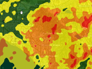
Heres a radar image of the pending storm: (The orange and red areas are areas of heavy precipitation)
With the ground already saturated from earlier storms, debris flows and mudslides in the area from the previous fire are highly possible.
Drivers are warned not to drive their vehicles into areas where the water covers the roadway as it may cause hydroplaning or stalling.
Lastly, areas located near streams and creeks are subject to flooding. If possible move to higher ground.
A call was issued to those registered with the OC ALERT County Program.
Heres a radar image of the pending storm: (The orange and red areas are areas of heavy precipitation)

Wednesday, January 20, 2010
Staying informed
Want up to the minute dopplar satellite images of the storm? Use the links at the right to keep up with traffic advisories, weather images, even lightening as they occour!
Click HERE to go to my favorite interactive map from ABC 7. You can zoom down to the street level and customise your alerts.
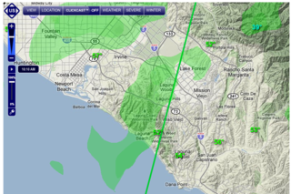
Screen Shot of ABC7 Interactive Radar
Click HERE to go to my favorite interactive map from ABC 7. You can zoom down to the street level and customise your alerts.

Screen Shot of ABC7 Interactive Radar
More than rain is falling....


..from the skies in Trabuco Canyon at night. Last night at 11:00 pm a sycamore tree fell on Alan Schumanns house on Trabuco Oaks Dr. No one was injured and the house is reported to be okay.
Preditctions about storm watch day three....
... is deffinitely more rain. The National Weather Service has announced that more storms are in the pipeline with storms lingering over the pacific that will likely affect orange County. The next storm is anticipated to arrive this afternoon and is reported to continue through tonight bringing more wind and flooding. This storm will be followed by yet another powerful storm this Friday.
The storm is anticipated to bring strong gusts, with windspeeds of up to 60 miles per hour. Conditions will remain favorable for tornadoes and waterspouts. The snow level is expected to lower to 4,000 ft which will make for a beautiful snow capped saddleback mountain range whose Santiago Peak sits at 5,687ft and Modjeska peak sits at 5,496 ft.
WIth an expected amount of rain to fall any where from 8 to 30 inches, depending on location- mudflows, debris flows and traffic blocks can be expected. Please be careful and patient while you are on the road.

Overview of the approaching storm system taken from intellicast.com
Tuesday, January 19, 2010
Rumbles in the night
... its the rumblings of yet another storm. A much smaller storm sits just south west of us and heralds its arrival, or soon to be arrival, with low and steady rumbles of thunder that pierce the stillness of the night.
Road Hazards
As the storm lightens road hazards are emerging. As reported by the CHP blotter on Plano Trabuco as one approaches the switch backs leading to Live Oak Canyon Road, rocks and debris from the roadsides are littering the road, causing drivers to swerve into the on coming lane to avoid the "larger than fist sized rocks" says Faith Hoffman- a Trabuco Oaks resident. "I looked at the road and the rocks were the size of my kid's heads. Thank God I had four wheel drive." mused Becky Weiskittle about her drive hime from RSM Intermidiate School. CHP also reports mud in the roadway on Live Oak Canyon Rd at O'Neil Park.
Road troubles weren't just limited to those enering the canyon. It caused a problem for those leaving as well. Patti Mode, also a Trabuco Canyon resident and Trabuco Canyon Elementry staff member was stranded momentaritly as her car became saturated on her travels up the hill. Other were stuck behind Hamilton Oaks gate as a minor mudslide prevented the gate from opening and residents from entering or exiting at Hamilton Truck Trail.
On the bridge that traverses Trabuco Creek, on Live Oak Canyon rd just before Rose Canyon, there is mud and debris on the road with approximately 6 inches of standing water. Sherifs are standing by, but still allowing traffic to pass through.
End of Tuesday storm Phase I
The storm has let up for a moment. The rain has ceased, for now. By assessing my homeade rain gauge deluxe (and by deluxe I mean a mason jar and ruler) it seems the last storm dropped an inch and a quarter of rain over a 1hr and 45 mins.
I HAVE ALSO RECIEVED WORD BY WAY OF NEIGHBOR THAT THERE HAS BEEN A MUDSLIDE AT EITHER HAMILTON OAKS OR IN HAMILTON OAKS. I'LL HAVE MORE ON THAT LATER.
CHECK OUT THE VIDEO OF THE TRABUCO CANYON RAIN GAUGE DELUXE:
I HAVE ALSO RECIEVED WORD BY WAY OF NEIGHBOR THAT THERE HAS BEEN A MUDSLIDE AT EITHER HAMILTON OAKS OR IN HAMILTON OAKS. I'LL HAVE MORE ON THAT LATER.
CHECK OUT THE VIDEO OF THE TRABUCO CANYON RAIN GAUGE DELUXE:
The eye of Tuesday afternoon's storm
Watch the rain pour down at 1:55 today. Water is rushing down lower Mountainview Rd at a rate that is much faster than what the storm drains can handle. The run off is pooling in front of my house and has risen higher than the Schwendeman berm and is actually running up and over the berm causing minor flooding of the property below it.
And here's another video of it pourin down in the back yard. God never ceases to amaze me with his power:
And here's another video of it pourin down in the back yard. God never ceases to amaze me with his power:
BOOM BABY!
The thunder storm has arrived. As of 1:25 PST thunderclaps could be heard rumbling low and angry. Low rumblings are approaching from the south west. Listen to the thunder roll... you might even be able to see the moment where the lightning flashes. What is it about thunder that makes you feel so small?
TORNADO WARNING!!!!
The NSA has issued a tornado watch for orange, tustin and irvine. The storm just passed through garden grove as I spoke to my Grandfather by phone a minute ago. He said it was really pourin down.
The Tornado warning is continued until 2:15 PST.
The Tornado warning is continued until 2:15 PST.
And rthe rain begins again.
Queue storm number two. Beginning just a couple of minutes ago, the rain has begun to fall again here in Trabuco Canyon. This time I put out my rain meter to gauge just how much rain has fallen during this Storm in my neck of the woods. Here's a video of the start of the storm. Notice the wind gusts.
According to the satellite images, the strongest parts of this storm are passing to the north west (Los Angeles) and South East (San Diego)- leaving just mild rain for us in the middle. (phew)
According to the satellite images, the strongest parts of this storm are passing to the north west (Los Angeles) and South East (San Diego)- leaving just mild rain for us in the middle. (phew)
Monday, January 18, 2010
A calm in the storm
The skies have calmed for a little while. Totals are pouring in for wind speed and rain fall in inches. Trabuco Canyons aw gusts of up to 30mph. Rainfall totals from the first and lightest anticipated storm are as follows- Santiago Peak has reported rainfall at 4.61 inches, with 2.44 inches in Silverado Canyon. Modjeska Canyon saw 1.65 inces of rain.
Our little canyon seemed to escape many of the incidents that befell other less fortunate. Some places in Costa Mesa have experienced some serious flooding as a drainage ditch was filled to capacity and overflowed. The rain and wind have also fallen some trees. A massive tree toppled over and crushed an unoccupied house in Dana Point. In Irvine, a man in his mercedes was injured by a falling eucalyptus tree.
As far as the storm goes, the OC register reports that a second storm will hit Tuesday afternoon, followed by another one Wednesday and Thursday that could proove to be stonger than the first two.
Every cloud has a silver lining....
...and here is optimism at it's best. While the rest of us are concerned with the storm, others are taking advantage of the great off-roading conditions at Holy Jim Canyon. Check it out:
Storm Watch video: Holy Jim 1.18.10 5:00 PST
I took advantage of the lull between storms to video the creek bed at Holy Jim Canyon. The canyon sits at the base of Saddleback Mountain and is a favorite for off road enthusiasts.
Storm Video: Hickey Creek 1.18.10 4:05 PST
Here is a video of the water level in Hickey Canyon Creek, Trabuco Canyon, Ca. Captured today at 4:05 PST.
Flash Flood Warning
The National weather service has issued a flash flood warning for the Trabuco Canyon area that begins at 4pm today and continues through this evening.
For further information please check the National Weather service website
For further information please check the National Weather service website
Calling all storm watchers
I am looking for people who have views of Holy Jim river bed, hickey creek and other water ways in Trabuco Canyon to submit their videos and pictures to help track the storm. Please leave your contact information in the comment section and I will get back to you as soon as possible.
Its raining, Its pouring
Hello all. I am writing this blog from my home in Trabuco Canyon. I live between hickey creek and Holy Jim Canyon and will use this blog to keep track of weather resources and track water levels in trabuco canyon near my home. Stay posted for video, links and images of the Trabuco Canyon storm watch.
Subscribe to:
Comments (Atom)
